


FORT WAYNE, Ind. — A Flood Watch has been extended for areas along and south of U.S. 30 as multiple rounds of thunderstorms are expected across the region Wednesday.
The National Weather Service in Northern Indiana says storms could continue through the late afternoon, with rainfall rates of 1 to 2 inches or more per hour possible.
The greatest chances for severe weather are expected between 11 a.m. and 5 p.m. Wednesday, mainly south of U.S. 30.
Damaging winds and heavy rain are the main threats, although hail and tornadoes cannot be ruled out. The severe weather threat could expand farther north.
The National Weather Service says additional heavy rain is possible in areas that received significant rainfall Tuesday. Some locations have already reported more than 5 inches of rain over a 24-hour period.
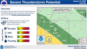
Residents are urged to remain weather aware and have multiple ways to receive weather warnings.

The National Weather Service says this is expected to be its last briefing on Wednesday’s event unless the forecast changes significantly.
