


FORT WAYNE, Ind. (WOWO) — Summer isn’t giving up just yet.
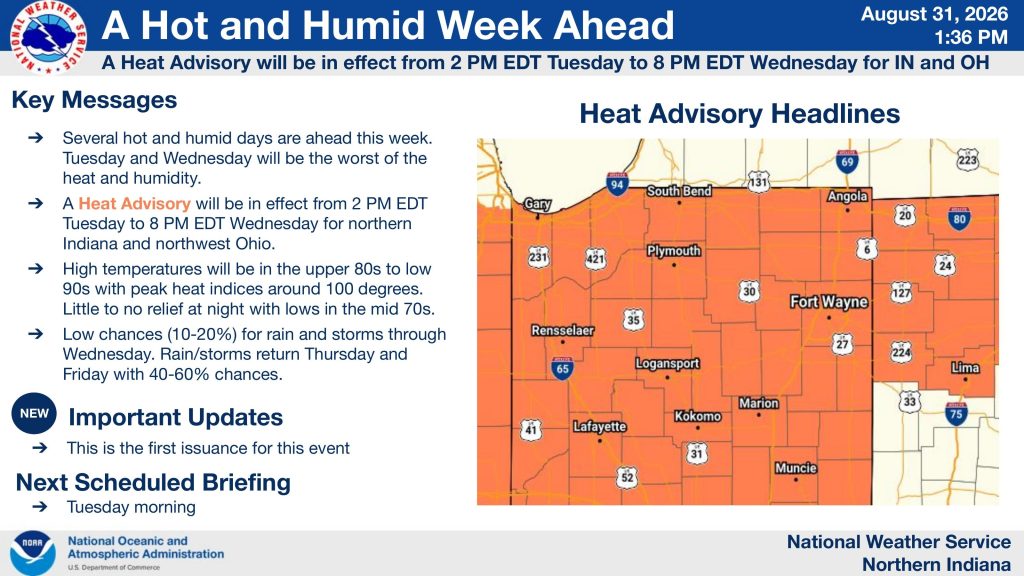
Northeast Indiana is headed into a stretch of hot and humid weather, with temperatures climbing into the upper 80s and lower 90s and heat indices approaching 100 degrees Tuesday and Wednesday.
The National Weather Service in Northern Indiana issued its first briefing on the heat Monday afternoon, with a Heat Advisory scheduled from 2 p.m. Tuesday through 8 p.m. Wednesday across northern Indiana and northwest Ohio.
Tuesday and Wednesday will be the worst
The NWS says Tuesday and Wednesday will bring the worst combination of heat and humidity this week.
High temperatures are expected to reach the upper 80s to lower 90s, while peak heat indices could approach 100 degrees. Overnight temperatures won’t offer much relief, with lows remaining in the mid-70s.
The detailed temperature chart on page 2 of the NWS briefing shows Fort Wayne reaching a projected heat index of about 97 degrees Tuesday afternoon, with the heat index climbing to approximately 101 degrees Wednesday afternoon. Wednesday is expected to be the hottest day of the week.
Other communities could also flirt with or exceed the 100-degree heat-index mark, including Logansport, Marion, Lima and parts of northern Indiana and northwest Ohio.
A few storms are possible
The heat won’t be completely uninterrupted.
There is only a 10% to 20% chance of rain and thunderstorms through Wednesday, according to the NWS. Better chances arrive Thursday and Friday, when rain and storm chances increase to 40% to 60%.
The NWS is also tracking a Marginal Risk — Level 1 of 5 — for severe thunderstorms Tuesday and Wednesday.
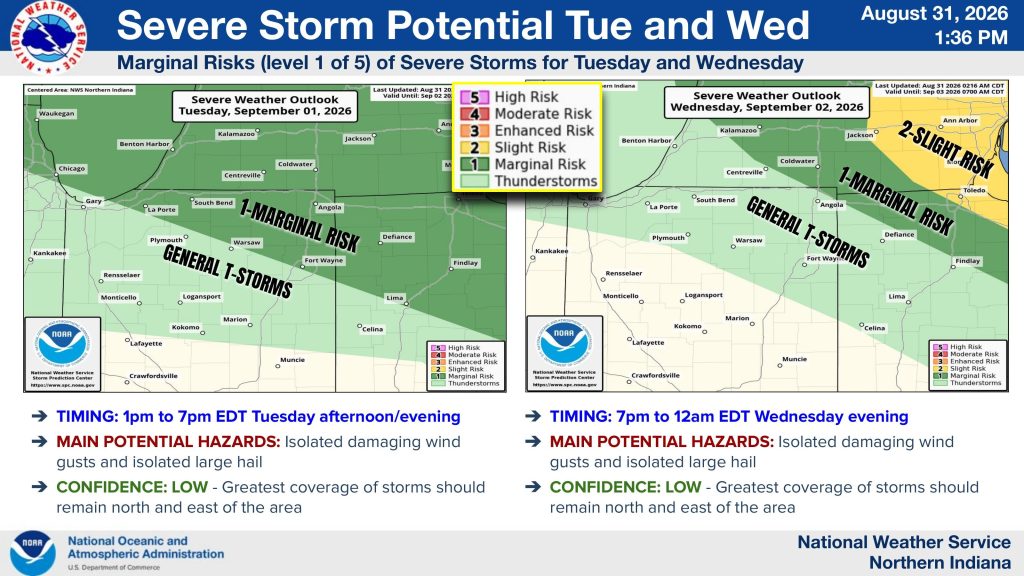
For Tuesday, the greatest potential for storms is between 1 p.m. and 7 p.m. The primary threats are isolated damaging wind gusts and isolated large hail, although confidence is low and the greatest coverage of storms is expected to remain north and east of the area.
Another round could develop Wednesday evening between 7 p.m. and midnight, with isolated damaging winds and large hail again possible. The NWS says confidence remains low.
Don’t underestimate the heat
The NWS is urging people to take precautions as the heat builds.
Drink plenty of water, even if you don’t feel thirsty, and try to spend time in air conditioning or the shade during the hottest portions of the day.

Wear loose-fitting, light-colored clothing if you have to be outside.
And perhaps most importantly: never leave people or pets alone inside a closed vehicle. The NWS warns that heat can escalate quickly and become dangerous. The safety graphic included with Monday’s briefing specifically emphasizes hydration, shade or air conditioning and avoiding enclosed vehicles.
When does it cool down?
The heat begins to ease later in the week as rain and thunderstorms become more likely Thursday and Friday.
For now, though, the message from the National Weather Service is straightforward: Tuesday and Wednesday are the days to watch.
The NWS is scheduled to issue its next briefing Tuesday morning, so the forecast could be refined as the event gets closer.
Stay with WOWO for the latest weather updates across Northeast Indiana.
