


FORT WAYNE, Ind. (WOWO) — Much of northeast Indiana and northwest Ohio face an elevated threat for severe weather Tuesday, with the greatest risk expected during the afternoon.
The National Weather Service in northern Indiana says the main window for severe weather will be from noon to 6 p.m., when a line of potentially powerful thunderstorms could move through the region.
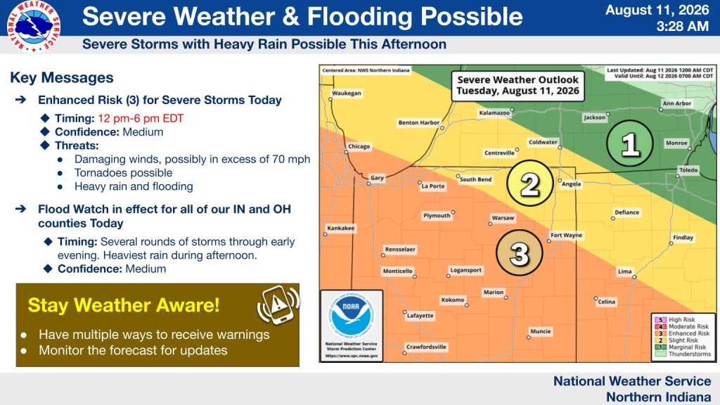
The greatest severe weather threat is expected along and south of U.S. 30, although areas farther north could still see strong storms.
Damaging Winds, Tornadoes Possible
The primary concern Tuesday is damaging straight-line winds, with wind gusts potentially exceeding 70 mph.
A low tornado threat also exists, with the National Weather Service placing the tornado probability at 2% to 4%, generally along and south of U.S. 30.
The overall severe weather threat is classified as an Enhanced Risk, Level 3 of 5, meaning numerous severe storms are possible and some could become long-lived or intense.
Storms are already developing Tuesday morning. Forecasters say those storms could continue through the morning and produce isolated severe weather or heavy rainfall before the main afternoon threat arrives.
Flooding Also a Major Concern
Heavy rainfall will accompany the storms, creating the potential for flash flooding.
A Flood Watch is in effect for all of the National Weather Service’s Indiana and Ohio counties covered by Tuesday’s briefing.
Rainfall rates of 1 to 2 inches per hour or more are possible, particularly during the afternoon.
Forecasters say there is a high potential for 2 inches or more of total rainfall, with localized amounts of 4 inches or more possible.
Flooding could be especially problematic in areas that have already received significant rainfall.
Drivers are urged to avoid flooded roadways. Turn around, don’t drown.
Wednesday Brings Another Storm Chance
The severe weather threat doesn’t completely disappear Wednesday.
A Marginal Risk, Level 1 of 5, is currently in place generally south of U.S. 30.
The primary threats Wednesday afternoon and evening will be damaging winds and localized heavy rain, although forecasters say confidence in the Wednesday forecast remains low.
Be Ready for Warnings
The National Weather Service is urging residents to prepare before Tuesday’s storms arrive.
Residents should:
- Have multiple ways to receive weather warnings.
- Know where they will take shelter if a warning is issued.
- Avoid driving through flooded roadways.
- Be prepared for potentially damaging winds.
- Monitor weather conditions throughout the afternoon.
The most significant threat for northeast Indiana is expected between noon and 6 p.m. Tuesday, but storms and heavy rain could develop before that window.
